You may have already seen some news and information about new products bringing one or more integrated Lidar sensors. The latest versions of premium iPhones feature LiDAR technology.
But, what is a Lidar sensor? What is it for? What does it represent?
For starters, let’s unravel what the name means. Lidar is the acronym for the words ‘Light Detection And Ranging‘, in free translation it would be “light detection and range”.
It uses remote sensing to measure the properties of reflected light. The technology as a whole can measure the correct distance between different objects.
This technology is usually present in specific devices (such as photographic cameras). Despite this, companies are also starting to explore the possibility of adding the sensor to some other gadgets.
It is present from simple devices, such as electronic rulers for architects (a laser that measures without having to hold a tape measure), to other more complex devices. Its operation will be detailed below. Its uses are quite varied and can be explored further.
What is a LiDAR sensor?
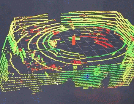
The Lidar sensor is a pulsed laser system. It is widely used for obtaining spatial information. As mentioned, it can measure and get the actual distance objects are from each other, but it can also be used to define measurements.
To know exactly how tall a tree is in Central Park, for example, an airplane with the sensor at the bottom can give this information precisely.
It can also be found by another name, LADAR (Laser Detection and Ranging). The applications, uses and technologies are the same, it’s just another way of being called. Generally, this nomenclature is found in military contexts.
How does LiDAR work?
Lidar can measure distances through light. Then the question may come: what about when the environment is dark?
How is this measurement made? Well, it is done normally, since the light source comes from laser beams in the near-infrared (IR) band, emitted by the sensor itself. It can model the terrain surface three-dimensionally.
The more beams present in the sensor, the greater its range. When it is used in environments with living beings – animals or people – the amount of light source is lower. A big benefit is that it is low energy.
This is because the beam is not very strong. If a very strong beam hits the vision, it can damage if it is too intense.
The larger the sensor, the more beams it will be able to emit. This is valid for satellites with Lidar, which orbit around the Earth. They can reach thousands of kilometers away with the same precision.
This is only possible due to a large number of beams. Molin also explains that the quality does not change, only the range. The distance of used devices usually has fewer beams, so as not to present problems to people.
This system can be present on both mobile and fixed platforms. This indicates that Lidar can be implemented in a tower, fixed to the ground, in an airplane, or even inserted into gadgets, along with several other sensors.
LiDAR combines the Global Navigation Satellite System (GNSS) and the Inertial Navigation System (INS).
The GNSS is responsible for providing the location of the aircraft in space, thus being able to inform where the objects are. The INS informs the altitude angles of what is being measured. To obtain the result, a calculation is made.
The variables are the elapsed time of the emission of the laser pulse to the target and its return time to the sensor.
The sensor converts time into the distance from the speed of light. After that, the value is associated with placement information. The result will show the 3D coordinates of the object in question. Laser pulses are emitted at a certain repetition frequency rate.
They act as a scanner, doing a kind of scan perpendicular to the direction of the line from which it is being picked up.
Lidar is a technology developed in the 1960s, which began to be explored in the 1990s. It is the use of a closed beam of laser light that does not open. Therefore, it has a very limited cone, this is its great virtue.
The system measures the speed the beam takes to return. The time it takes him to hit and come back. In general, it is a distance meter.
In this way, the Lidar Sensor can achieve multiple reflections. This means that several pulses can be reflected from the same object. The technology manages to obtain high precision results in its analyses.
For this reason, it is used militarily, by space missions, for accurate terrain measurements, and is starting to be implemented in everyday features. We will detail these uses below.
In general, the models used typically range from 2m to 5m. As already mentioned, this is due to the necessary care. Depending on the uses, the range may be different. This is the case for aircraft or satellite applications.
Applications and Uses of LiDAR
Okay, after understanding how the sensor works, comes the next step: what it is for? We’ve already mentioned some of their uses, but let’s go into a little more detail about the functions they can have.
We say that the Lidar Sensor acts like a scanner, managing to scan the environment. That is, it can accurately tell which objects are in their “vision” radius. It can detect any type of body, whether a moving object or not.
One of the most “noble” uses will be in autonomous vehicles, aircraft, and machines.
We start with an example a little further away. Self-driving cars are receiving more and more investments – with Tesla as a leader in the segment. Even though it doesn’t seem like a close reality, its uses are increasingly expanded.
Although we think only of cars, agricultural machines already make use of these technologies.
We emphasize that Tesla makes use of its technology. The company has camera systems on the sides of the car, which identify the environment and process using cutting-edge computer technology.
Although the company has researched Lidar, it is not widely used in their cars. The models available on the market are not equipped with sensors.
The technology is used in engineering projects primarily to obtain accurate topographic surveys. It is especially important for the elaboration of digital models intended for exact studies of the environment.
That’s because it can provide accurate information very quickly. It can adapt to spaces with a lot of vegetation, such as in very urbanized environments, with a large volume of constructions.
Knowledge areas that use Lidar sensors:
- geodesy (a subdivision of geophysics concerned with determining the dimensions and shape of the Earth)
- archeology
- architecture
- geography
- geology
- geomorphology
- seismology
- Forest engineering
- coastal oceanography
- remote and physical sensing of the atmosphere
Generally, a specific device is used with the sensor. It can take the measurement and deliver the best result to professionals who need the data. Despite this, it seems that its uses have been expanded and can be added to other products.
1. Gadgets with Deal
It is normal for a technology to be explored in different ways, adapting to different needs. Apple introduced the Lidar sensor in the 2019 iPad Pro.
According to the company, it “measures the distance of up to five meters from objects in the environment in nanoseconds”. Its uses are linked to augmented reality technologies.
With the rise of cameras in smartphones, most companies add a ToF (Time of Flight) sensor. It is an additional lens, which is used to measure distances between objects, assist with secondary effects of photography, etc.
For this reason, some people wonder if using a Lidar sensor couldn’t be more effective.
2. Lidar sensor on smartphones
This technology could be present in smartphones, but in what form? What would its actual uses be? Let’s remember that everything is still in its initial testing phase. It can be a niche device, for example. Companies have not yet explored the functions much.
Generally, the Lidar sensor is very connected to Augmented Reality. We talk about its uses for shopping, for example. This is just one possibility.
That’s because it can even be used in games. It will also be essential to research Frontier internet prices and ensure a quality internet for the resource to work correctly.
The sensor could be located in the same location as your smartphone’s camera settings. The main uses may be related to games.
Therefore, it may be that the first options that can bring the sensor are devices dedicated to the gamer market, such as Asus ROG Phone, Xiaomi Black Shark, Nubia Red Magic, among other options.
Conclusion
The uses are numerous. As technology expands, more can be done. Today, there are already “digital rulers” that make quick measurements of environments. They are widely used by architects, for example.
This feature can be inside the smartphone itself, preventing another device from being taken. Of course, as new features appear, more functions emerge and are explored.
In addition, it will be important to have access to good phone and internet bundles to ensure proper functioning.